BEIJING, Nov. 15 (Xinhua) According to the latest weather forecast, affected by strong cold air, there will be a large-scale gale cooling and rain and snow weather process from north to south in China from 16th to 18th. The temperature will drop by 8 ~ 10℃ in most parts of the central and eastern regions, and the temperature will drop by more than 12℃ in some areas. There are 4 ~ 6 northerly winds in most areas north of the Yangtze River, and the gusts can reach 7 ~ 8.
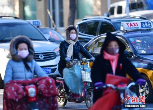
Cold air has caused temperatures in Northeast China and North China to hit a new low in winter.
In November, several rounds of cold air continuously pulled many places in China from late autumn to early winter from north to south, and some areas ushered in the first snowfall or "coldest day" in the second half of the year.
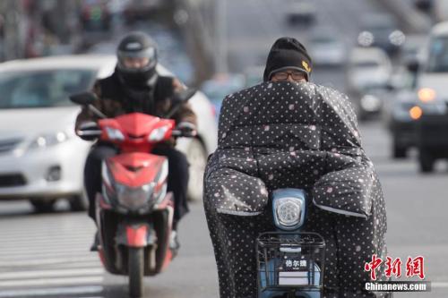
Taking the 14th as an example, the temperatures in Northeast China, North China, Huanghuai and other places dropped significantly, with most areas in Northeast China and North China spending the coldest day since this winter.
According to the weather forecast, the highest temperature in the north-central part of Northeast China and the eastern part of Inner Mongolia fell below freezing point on 14th, while the lowest temperature dropped below minus 10℃. For Harbin, Changchun and many other places, it is the first time this winter to experience that the temperature is below 0℃ all day, and the highest temperatures in Beijing and Tianjin will also hit a new low this winter. It is estimated that by the 15th, Beijing, Shijiazhuang and other places in North China are expected to refresh the lowest temperature since the second half of this year.
Sun Jun, chief forecaster of the Central Meteorological Observatory, said that the cold air currently affecting the central and eastern regions began to affect China on the 13th, and the impact period was mainly concentrated on the 13th and 14th.
"The current round of cold air has a small influence range and weak intensity, mainly affecting northeast China, North China, Huanghuai and Jianghuai areas. The cooling range reaches 4 C-6 C, and the local area exceeds 8 C. At the same time, the above areas are accompanied by 4-5 northerly winds." Sun Jun said.
According to reports, as far as the cooling situation is concerned, in this round of cooling, the cooling rate in Hebei is relatively large. Among them, from 8: 00 on the 13th to 8: 00 on the 14th, the temperature drop in mountainous areas in western Hebei, such as Zanhuang, Lincheng and Neiqiu, reached more than 10℃. During the daytime on the 14th, the temperature in the eastern part of Northeast China, Huanghuai and Jianghuai areas will be lower than that on the 13th. At present, the front of this cold air has reached the middle and lower reaches of the Yangtze River, but it will not continue to affect Jiangnan and South China southward.
A new round of strong air conditioning has cooled down locally in the middle and east of the road or exceeded 12℃
However, when people in Northeast China and North China are discussing the new low temperature, a new round of strong cold air with larger scope and wider influence is already on the way.
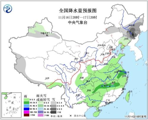
According to the forecast, starting from the night of 16th, a new round of strong cold air from the Mongolian Plateau will enter China, Inner Mongolia and northern Xinjiang, and will affect most of the central and eastern regions from north to south. Affected by this, there will be a large-scale gale cooling and rain and snow weather process from north to south in China from 16th to 18th.
According to meteorologists, the intensity of this round of cold air is stronger than that of the cold air from 13th to 15th, and its influence is wider, which will have a more obvious impact on the cooling in the southern region. In addition, the impact of this round of cold air process is mainly caused by strong winds.
According to the forecast, due to the influence of this round of strong cold air in the future, the temperature in most parts of the central and eastern regions will drop by 8 ~ 10℃, and the temperature in some areas will drop by more than 12℃, and the ground minimum temperature line of 0℃ will be pressed southward to the area along the Huaihe River in the early morning of the 19th. There are 4 ~ 6 northerly winds in most areas north of the Yangtze River, with gusts of 7 ~ 8, and 7 ~ 9 winds in the eastern and southern seas.
In terms of precipitation, there will be small to medium snow or sleet in most parts of eastern Inner Mongolia and Northeast China, heavy snow in eastern Jilin, small to moderate rain in Huanghuai, Jianghuai, Jianghan, Jiangnan, eastern Southwest China and South China, and heavy rain in parts of Jiangnan. In addition, from 16th to 17th, there was little to medium snow or sleet and local heavy snow along Tianshan Mountains in northern Xinjiang.
"This round of cold air process has the characteristics of fast moving speed, wide influence range and large cooling range. Cold air entered Inner Mongolia from the night of 16th to the middle and lower reaches of the Yangtze River on the night of 17th. On the night of 18th, cold air will continue to move southward and reach the South China Sea. It can be said that in just two days, it swept across most areas in central and eastern China from north to south. " Sun Jun introduced.
Regarding the impact of cold air on agriculture, Sun Jun introduced that around the 19th, early frost will appear in parts of the western and southern parts of Huanghuai, Jianghuai and other places, and the windy and cool rain and snow weather is not conducive to facility agriculture and animal husbandry production, late sowing of winter wheat and the growth of open-field vegetables. For the southern region, the rainfall in the south of the Yangtze River from 17th to 18th is slightly unfavorable to the drying of autumn harvest crops such as late rice, fruit harvesting and the robust growth of autumn sowing crops, but it is beneficial to increase the storage capacity of reservoirs and ponds.
Why is cold air so frequent when winter comes too late?
Recently, the cold air affecting China has been coming one after another. The temperature in many places from north to south has dropped rapidly in a short period of time, and many netizens lamented on social networks that "winter came off guard".
For the frequent cold air attack, Sun Jun analyzed that the fundamental reason for the frequent cold air process in China in autumn and winter is the difference in thermal properties between land and sea.
"In autumn and winter, the land will form a strong high pressure, and the ocean will form a low pressure. The horizontal pressure gradient force will make the atmosphere move from a place with high pressure to a place with low pressure. From the perspective of climate system, the reason why cold air frequently moves south in autumn and winter is that the subtropical system and tropical system move south, the warm and humid airflow moves south, and the ground cold high pressure tends to be active in the middle and high latitudes, so the northwest airflow guides the cold air mass to move south. " Sun Jun said.
In the recent "Direct Weather — — In the program "Talking to Scientists", Wang Yongguang, the chief climate expert of the National Climate Center, predicted this winter’s climate, and said that from the previous data forecasting model and diagnostic analysis, China may still be warmer this winter, "the impact of warmer air quality can not be ignored, including Beijing-Tianjin-Hebei region and Yangtze River Delta region, and it is still necessary to strengthen prevention".
As to how to define "cold winter" and "warm winter", Ding Yihui, academician of China Academy of Engineering and special adviser on climate change of China Meteorological Bureau, explained that the climate change can be described by two parameters, one is the average temperature, and the average temperature of a winter for 90 days exceeds the average for many years, which is warm winter, and the other is cold winter, which is the problem of average. Another parameter is extreme events, such as sudden and violent cooling in a few days in a winter and cold wave weather.
"If the average is a warm winter, it does not mean that there will be strong cold events and warm events under this warm winter." Ding Yihui said.